 |
|
|
|
Trails of the Diablo Valley East Bay Regional Park District Trails East Bay Municipal Utility District Trails |
Great Northern California TrailsWhile California is a large and diverse state with many natural and scenic wonders, Northern California is particularly blessed with some of the most fantastic scenery in the world. Only 4- and 5-star areas are listed, and as such - if you are in the vicinity and enjoy natural beauty at its finest - should not be missed. Not all trails are located in wild areas, since some of the most spectacular scenery is found in urban settings. California - particularly Northern California - has acted to preserve public access to many areas of scenic significance, and to protect these areas from development which would infringe upon its beauty. I will only attempt to describe trails that I have personally done. These trails offer only a sampling of what these areas have to offer - there may be other trails that are even more spectacular. You should always check locally for recommendations to fit your specific interests. However, even the 'worst' trail in any of these areas is most likely better than the 'best' trail in many areas! |
Location & Directions: Marin County; 17 miles north of San Francisco by way of the Golden Gate Bridge and U.S. 101 and California Highway 1.
Hours: 8AM to sunset year round.
Notes: This is an extreamly popular park and given its proximity to San Francisco is always crowded. Parking can be difficult on weekends and holidays. Pick up a trail map and nature guide at the visitor center. Due to the crowds and the many interesting exibits this is an area for walking, not running. No pets or bikes are permitted in the park.
| Trailmap (103K) | Open Map in New Window | Contact Information |
Main Trail - Hillside Trail Loop (2 miles):
![]()
![]()
![]()
![]()
The Main Trail begins at the visitor center and follows Redwood Creek on both sides of the creek for .5 miles to Cathedral Grove. Continue past Cathedral grove another .5 miles to 4th bridge. At the Hillside Trail sign walk uphill for about 40 yards, to where the path curves along the Canyon edge and doubles back around a side stream. Take the Hillside Trail 1 mile back to the visitor center.
Related Sites:
|
Notes: Maps and information are available at the Visitor Center (hours: 9:30am to 4:30pm) on Bunker Road. Dogs are required to be leashed unless otherwise posted. Campsite and group camps can be reserved by calling (415) 331- 1540.
| Trailmap (115K) | Open Map in New Window | Contact Information |
Coastal - Miwok - Wolf Ridge Loop (5 miles) ![]()
![]()
![]()
![]()
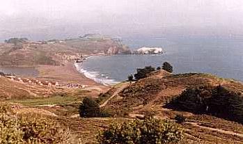
Trailhead: Rodeo Beach
Directions: From San Fracisco cross the Golden Gate Bridge and exit at Bunker Road (Ft. Baker). Go left (west) on Bunker Road through the tunnel under the freeway and continue all the way to Rodeo Beach.
This is a moderate 5 mile loop with several hundred feet of elevation gain. From the parking lot go south along the beach and pick up the trail on the south side of the lagoon. Follow the trail along the lagoon for about .5 miles, cross the lagoon on the bridge to the intersection with the Miwok Trail and go right. Take the Miwok Trail for 1.8 miles to Wolf Ridge Trail and turn left. Go .7 miles to the Coastal Trail, bear left and take 1.6 miles back to the trailhead. This trail provides a little of everything the park has to offer, a romp on the beach, sweeping views of the Pacific and access to WWII coastal batteries.
Notes: Picnic area, restrooms and drinking water are located at the trailhead.
Related Sites:
(8 miles each way) Pick up the trail in Monterey as it runs parallel to the bay 1/2 block inland from Cannery Row. Go south on the bike path to Pacific Grove where the path becomes a hardpacked sand footpath. Pass Lover's Point Park after 1 mile and then Point Pinos Lighthouse after another 1+ miles. Here the path parallels Ocean View Boulevard and then enters Asilomar State Beach for another 1+ miles. Just past the end of Asilomar Beach look for a path that goes off to the right and through the Beachcomber Inn and Spanish Bay Resort. Take this path, occasionally traveling over wooden walkways, as it winds through the dunes to Spanish Bay Road and Moss Beach along the 17 Mile Drive. An alternative is to take Sunset road past Asilomar Beach to Seventeen Mile Drive and turn right. Sign in at the entrance (free to pedestrians and cyclists) and continue to Spanish Bay Drive where you go right to Moss Beach. At Moss Beach the trail parallels Spanish Bay Drive along the ocean for about .7 miles to Point Joe. From Point Joe to Seal Rock is another 2+ miles with the trail paralleling Seventeen Mile Drive and the ocean. If at any point along the trail it seems to end, or when in doubt, use the bike path along the road and the trail will shortly re-emerge. A note of caution: be aware of the traffic as it can be heavy and most drivers are tourists who are just as overwhelmed by the sheer magnificence of the beauty as you are!
Notes: Restrooms, drinking water and picnic areas located at numerous places along the route. Dogs must be leashed.